Aerial views
 Balantraid Farm
 This is Balintraid Farm taken from the air in 1978. Mr. Forsyth who owned the Farm sent me the photo...
 Aerial view of Invergordon
 A copy of an aerial view taken 9th October 1946. The quality is not very good but the Large Version ...
 Invergordon Castle Grounds
 An aerial view of the Castle grounds taken on 23rd May 1946. The Large Version may yield more detail...
 Handley Page Heyford
 In 1937 the expansion of the runways and facilities at RAF Novar enabled larger aircraft to use the ...
 Handley Page Harrow
 In September 1939, No. 8 Air Observers School was formed at Evanton and operated Harrows, Henleys, W...
 Invergordon
 Here is an old photo of Invergordon, date unknown. Shore Road seems to be just a gravel track, but a...
 Invergordon Harbour
 The harbour area and the town, looking north. The fence around the Royal Naval facility can be seen....
 High Street Aerial View
 The picture is part of an aerial photograph taken by the RAF on 19th June 1947. The view is pointing...
 Steeplejacks at Rosskeen Free Church I took these photos from the top of Rosskeen Free Church steeple in April 1993 a week after the stee...
 Cromarty Firth looking east In the foreground is Highland Deephaven and the former site of RAF Evanton and, before that, Novar A...
 Aluminium Smelter The Smelter fully operational.
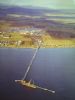 Saltburn Pier and the Smelter An aerial view looking north of the Pier and the fully operational Smelter.